This is one of the most complicated Sectional Chart excerpts you’ll encounter. It’s crowded and difficult to interpret. Take your time to first identify where Dallas Executive airport is located.
This question is asking us about the airspace that covers the towers that we are inspecting 9 statute miles SouthWest of Dallas Executive Airport. Looking at the chart, you want to locate the towers with the light icon above them, the tower almost looks like an M with sparks on top.
Looking specifically at the towers 9 SM southwest of the Dallas Exec you may think that the towers are located in Class G airspace.

However, if you zoom out a bit and look at the outer edge of the airspace, you’ll notice there is a thick fuzzy magenta line that envelopes the entire Dallas Fort Worth airspace. This indicates that Class E airspace starts at 700 ft AGL anywhere inside of the thick fuzzy magenta line.
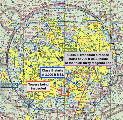
So, if you were to fly 400 feet above the tower in question you would be at an altitude of 2,949 ft MSL or 2,131 ft AGL. Here’s how the airspace stacks up from the surface to Class B.
Class B – starts at 3,000 ft MSL
Class E – starts at 700 ft AGL and extends up to 2,999 ft MSL (400 feet above the top of the towers (2,949 ft MSL) places you in Class E airspace
Class G – starts at the surface and extends up to 699 ft AGL