• Skip to primary navigation
  • Skip to main content
  • Skip to footer

Drone Pilot Ground School

FAA Drone Training & Part 107 Test Prep

  • Pricing
  • How it Works
  • Solutions
    • Teams
    • Schools
    • Hands-On Training
  • Reviews
  • About
    • Our Curriculum
    • Meet the Team
    • Giving Back
    • Contact Us
  • Resources
    • Find Your Nearest FAA Drone Testing Center
    • Browse Our Knowledge Base
    • Read Our Pilot Guides
    • FAQ
  • Log In
  • Sign Up

July 28, 2016

How to Read a Sectional Chart

Over the last few weeks, I’ve been getting a lot of questions about how to read a VFR Sectional Chart. I think a lot of people are seeing practice questions like this from the FAA’s sample UAG exam, and they’re trying to figure it out if they really need to be able to interpret a Sectional Chart during the UAG Part 107 Aeronautical Knowledge Test.

Short answer? Yes, you’ll need to understand how to read a Sectional Chart.

how to read a sectional chart part 107 drone test

What’s a Sectional Chart?

A VFR Sectional Chart is like a road map for the sky. It shows geographical and manmade obstacles, certain airspace boundaries and a plethora of other important pieces of information in amazing detail.

If you’re looking at a VFR Sectional Chart for the first time, it can be a bit overwhelming.

But it gets easier, I promise.

On your Aeronautical Knowledge Test, the chances of you needing to interpret something on a Sectional Chart are pretty high. We’ve dedicated an entire lecture in Drone Pilot Ground School to teaching people How to Read a Sectional Chart, and I just wanted to share one of the images from one of our slides to show you the kind of detail that we go into:

airspace sectional chart drone exam

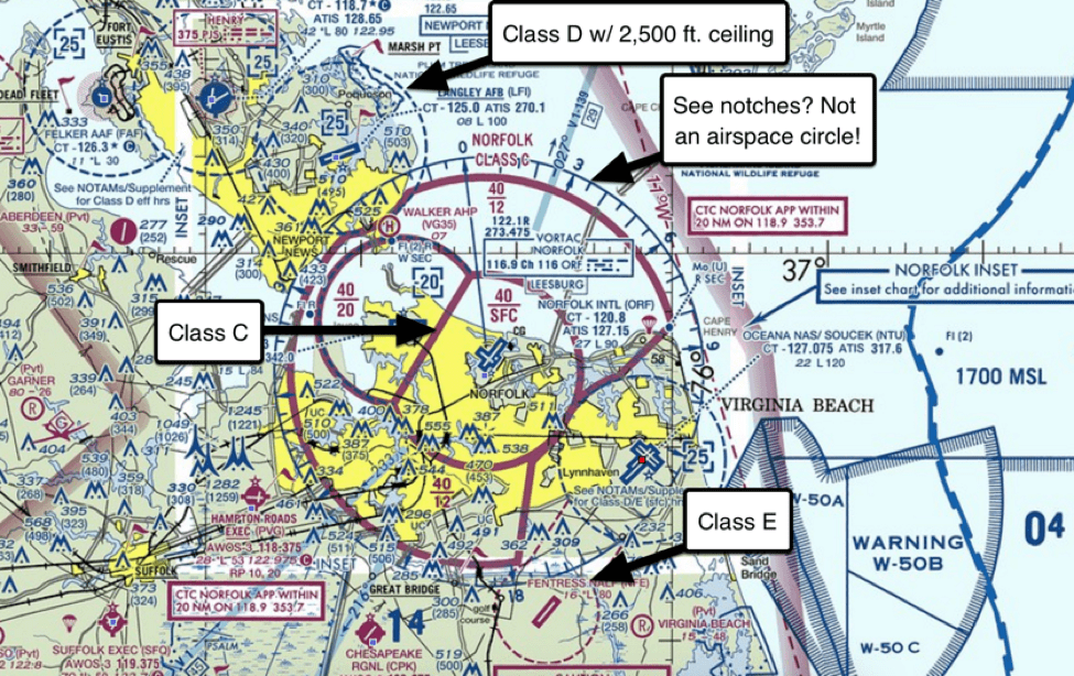
And that’s just airspace designations!

Fortunately, during your in-person test, you’ll be given a Supplement of charts and graphs, and in that resource you’ll find the following legend:

Sectional Chart legend drone test

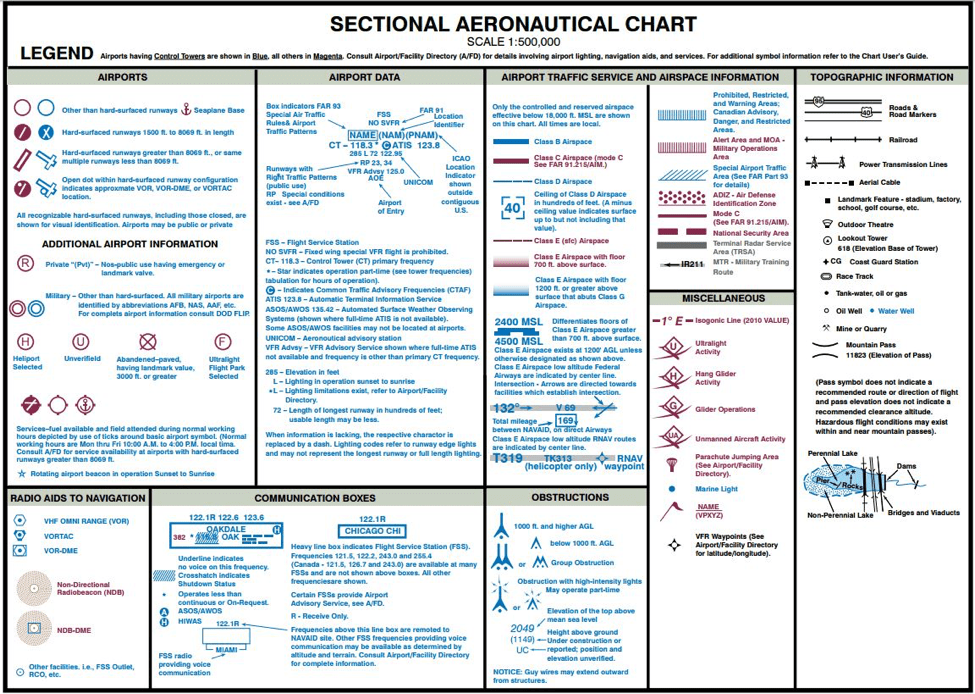
So no, you won’t need to memorize each and every minute detail of a Sectional Chart, but you WILL need to spend some time familiarizing yourself with how they work, and how to recognize and perform common interpretations like Maximum Elevation Figures, airspace classes, MSL vs. AGL altitudes, latitudinal and longitudinal charting, and more.

All of this (and more!) covered in Drone Pilot Ground School 🙂

Filed Under: Studying for the Part 107 Exam

Footer

Managed by UAV Coach

More than 30,000+ students trust Drone Pilot Ground School, a training program managed by UAV Coach, the largest and most reputable online-based drone training academy in the sUAS industry.

100% Secure Payment

Reviews

Common Questions

How long does the process take?
Do you guarantee I’ll pass?
Where is my closest FAA test center?

Recent Articles

  • How to Take Your Recurrent Exam and Renew Your FAA Part 107 Remote Pilot Certificate
  • FAA Issues Final Rulings on Remote ID, Flying at Night & Flying Over People and Moving Vehicles
  • How To Register Your New Drone With the FAA
  • How To Get Drone Flights Approved in Controlled Airspace with LAANC
  • How To Request FAA Airspace Authorization For Class B, C, D, And E Controlled Airspace: A Guide to LAANC and the FAA Drone Zone Web Portal

Contact Us: (888) 626-1490 // sales@dronepilotgroundschool.com
Phone Hours: Mon-Fri 9a-5p CT

© 2014-2020 UAV COACH, ALL RIGHTS RESERVED.

  • Privacy
  • Terms of Use
  • Sitemap