Want to get instant LAANC authorization?
This guide walks you through how to do that—jump down to the LAANC authorization section, or keep reading to learn more about what LAANC is and how it works.
Here’s a menu for this LAANC guide in case you’d like to jump around:
- What Is a LAANC Authorization?
- How to Get LAANC Authorization
- LAANC Apps: Best Software Options for LAANC Authorizations
- Where Can You Fly with LAANC?
- Understanding the Gridded Numbers

What Is LAANC Authorization?
LAANC authorization is an almost-instantaneous process that lets you get immediate authorization to fly in controlled airspace.
As a drone pilot, the most important regulation you will follow while flying your drone has to do with the National Airspace System—specifically, understanding whether or not you’re in controlled or uncontrolled airspace.
If you want to fly in controlled airspace, you’ll need to get authorization from the FAA to do so. And this is where LAANC comes in, acting as an expedient way for drone pilots to secure that authorization.
LAANC provides drone pilots:
- Access to controlled airspace at or below 400 feet.
- Awareness of where drone pilots can and can’t fly.
LAANC is also used by Air Traffic Professionals to get visibility into where and when drones will be operating near them.
Who Can Use LAANC?
Both commercial drone pilots and recreational flyers can use LAANC.
Here are the FAA’s requirements for each category of pilot:
- Commercial drone pilots operating under the Part 107 rules must register your drone and hold a Remote Pilot Certificate.
- Recreational flyers must register their drone and take the Recreational UAS Safety Test (TRUST) before their first flight.
Airspace Authorizations and the Advent of LAANC Approvals
Before LAANC, the process for securing airspace authorization for a drone flight in Class B, C, D, and some Class E airports was slow, manual, and cumbersome.
Here’s what you had to do:
- Submit a request via the FAADroneZone.
- Then wait—sometimes as long as three months.
In reality, all the FAA was doing to approve or deny these requests was manually reviewing the UAS Facility Map for the airspace in question, then using that map to say yes or no.
[A UAS Facility Map “shows the maximum altitudes around airports where the FAA may authorize part 107 UAS operations without additional safety analysis.”]
So the information itself was already available and you could know in advance whether you’d be approved. But actually getting the approval required waiting for a person to go look at the information and tell you that.
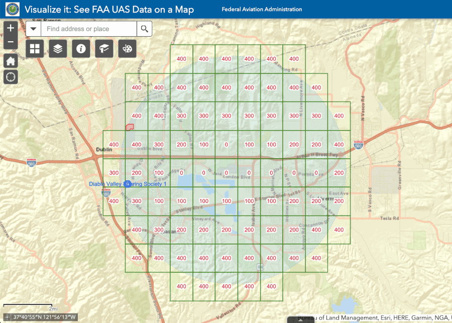
A UAS Facility Map
As you can imagine, this process could prove frustrating—especially if you had a drone job lined up and everything was riding on the arrival of that authorization.
How LAANC Requests Speed the Process from Months to Minutes
The LAANC approval process automates what used to be a manual review of UAS Facility Maps.
Here’s how LAANC requests generate instant approvals:
- A drone pilot submits an airspace authorization request using an app that offers LAANC services.
- The app automatically reviews the request using UAS Facility Map data.
- If the Facility Map allows the flight then it’s automatically approved.
Credit: The FAA
That’s it. No waiting for months on end for a manual review to tell you what you already know (if you have the Facility Maps on hand).
It’s worth noting that LAANC is available for both commercial / Part 107 regulations, but also for hobbyists loo
How to Get LAANC Authorization
The most common way that drone pilots use LAANC is to get approval to fly below the designated altitude ceiling on a UAS Facility Map.
Keep reading for a step-by-step guide on how to get LAANC authorization for this type of request.
*Need to fly above the designated ceiling? You can get permission to do this by submitting a “further coordination request” to the FAA. (These requests are only available to Part 107 pilots.)
Sep 1. Choose a Service Provider
Select an FAA-approved UAS Service Supplier (USS) that provides LAANC services. (We’ll cover LAANC apps in the next section.)
Step 2. Create an Account
Sign up with your chosen USS and set up your pilot profile. You’ll need to provide basic information such as your name, contact details, and Part 107 certificate number.
Step 3. Plan Your Flight
Use the USS app to create a flight plan. Input details such as the location, date, and time of your flight.
Important: Ensure the flight area is covered by LAANC (not all flight areas are!).
Step 4. Request Authorization
Submit your flight plan for LAANC authorization through the app. The request should include your maximum altitude and the duration of the flight.
Step 5. Receive Instant Authorization
In most cases, LAANC authorizations are automated and you can receive approval in near-real-time. Check the app for a confirmation of your flight authorization status.
Things to keep in mind:
- Check for updates. Before the flight, recheck the airspace status and any relevant NOTAMS (Notices to Airmen) or TFRs (Temporary Flight Restrictions) that might affect your planned operations.
- Fly responsibly. Once you get your LAANC authorization make sure to fly your drone within the parameters approved by LAANC and always adhere to FAA regulations and guidelines for safe flight.
LAANC Apps: Best Software Options for LAANC Authorizations
The instant airspace authorizations LAANC provides are powered by LAANC apps created and supported by private companies.
These apps act as the medium between flight planning and approvals from the appropriate Air Traffic Control.
A LAANC app allows you to use either your drone controller, smartphone, tablet, or desktop PC to submit a request to fly in controlled airspace and receive your approval, often within minutes.
All the LAANC App Providers
Here are all the companies that offer LAANC apps for instant airspace authorization:
- AirMatrix
- Airspace Link
- AstraUTM
- AutoPylot
- Avision
- Botlink
- eTT Aviation
- FlightReady
- UASidekick
- Wing
Learn more about each company’s LAANC app on the FAA’s website. (To see LAANC service providers, search “Approved LAANC UAS Service Providers.”)
LAANC Apps that Also Support the FAA’s B4UFLY App
The list of LAANC apps is pretty long—one way to narrow it down is to consider only those companies that offer both LAANC and the FAA’s B4UFLY app. (B4UFLY is the FAA’s app made to help recreational flyers understand where they can and can’t fly.)
Here are the four companies that offer both LAANC and B4UFLY:
- Airspace Link. Offers an all-encompassing, cloud-based drone platform named AirHub.
- AutoPylot. Develops an end-to-end solution for flight planning, in which drone pilots can get mission management data, airspace data, and LAANC authorizations in a single dashboard.
- Avision. Makes airspace and flight management solutions tailored for drone operations.
- UASidekick. Focuses on providing services to the aviation industry, especially for drone or UAV operations.
Where Can You Fly with LAANC?
LAANC is currently available at 541 LAANC Enabled Facilities and 726 airports throughout the U.S. View all the airports that offer LAANC authorization here.
Don’t see the area where you plan to fly on the list? Unfortunately that means you’ll have to submit a manual application to secure airspace authorization for your flight. That can be done at the FAADroneZone.
One thing to note–even if the airport where you want to fly doesn’t have LAANC, you can still use UAS Facility Maps to see whether your flight will be allowed.
This means you can do your research in advance, and know whether you’ll be able to fly there. So even though approval will take longer than it would with LAANC, at least you can know if you’ll be approved.
Understanding the Gridded Numbers
A question that often comes up related to LAANC and doing airspace research with UAS Facility Maps is: How do I use the gridded numbers? We’ll cover the answer in this final section of this LAANC guide.
In the photo below, we’ve selected a location to fly using our Part 107 certification, and when flying in the yellow outlined grid, our flight will be approved automatically when flying 100 feet AGL (above ground level) or below.
If you need to fly higher than 100 ft. in that part of the map, you’d still apply for authorization through LAANC.
Because you’re asking to fly over the UAS Facility Maps max gridded-altitude, your request may still be approved but would need coordination with the local airport and additional FAA safety analysis. This process typically takes 1-2 weeks, and it’s important to know that these situations are very much looked at on a case-by-case basis.
If you apply for authorization to fly your drone smack-dab off an LAX airport runway, odds are that’s not going to get approved in 1-2 weeks, probably at all without some serious back-and-forth and regulatory counsel.
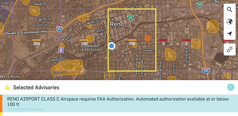
Within the yellow grid, our flight was automatically approved for a flight plan pertaining to 100 feet AGL and below using our Part 107 certification.
It is also worth mentioning that in this example, the flight grid we selected immediately becomes 0 ft AGL one quadrant to the right. And one and two quadrants to the left, you’ll see max altitudes of 100 ft. AGL and then 300 ft. AGL.
In the 0 ft. AGL grid, you wouldn’t be able to get near-instant authorization through LAANC. But you’d still apply through that system, knowing that you’ll eventually be asked to provide more information.
Get Started Today
Without question, the best application of your drone education is becoming familiar with the airspaces where you plan to fly.
But beyond the airspace, what kind of additional challenges will come with your intended flight? Are there a lot of people who frequent the area? Is your line of sight obstructed by buildings and trees?
While LAANC has revolutionized the ability to access locations for flight, it doesn’t make complex assignments any easier. If you feel nervous about flying your drone or want to improve your piloting skills, we invite you to look into our hands-on drone flight training in an area near you.