
Some of the most common questions we get from our students studying to pass their FAA Aeronautical Knowledge Test for a commercial Remote Pilot Certificate have to do with controlled airspace:
- What tools should I use to conduct airspace research?
- Can you help me understand whether or not I’m in controlled vs. uncontrolled airspace?
- Can’t I just contact the airport / air traffic controller directly to ask for authorization?
- What’s this I hear about an online portal and a 90-day wait-time?
- And what’s all this buzz about LAANC, UAS facility maps and instant airspace authorization?
In this guide, we’ll help you understand how to request airspace authorization to operate in controlled airspace. This guide is written for both recreational and commercial drone pilots.
We’ll teach you what controlled airspace is, how airspace authorizations are different from waivers, how long airspace authorization takes, and how to properly request airspace authorization.
So, without further ado, let’s get into the questions.
How a Drone Pilot Should Request Controlled Airspace Authorization
Q: What is a Sectional Aeronautical Chart?
Q: How can I tell if airspace is controlled or uncontrolled?
Q: What are the best apps / tools for researching airspace?
Q: Using LAANC to request instant airspace authorization [Popular Topic]
Q: What happens when LAANC doesn’t work?
Q: What is airspace authorization, and how is it different from an airspace waiver?
Q: Are airspace authorizations and airspace waivers different than getting a “Part 107 waiver?”
Q: What if I need a Part 107 waiver AND airspace authorization?
Q: I heard I could just contact the airport / air traffic control directly…isn’t that faster?
What is a Sectional Aeronautical Chart?
The Sectional Aeronautical Chart is the FAA’s official source of data when it comes to topographical features that are important to pilots operating in the National Airspace System (NAS).
Often just called a Sectional or Sectional Chart, these maps are updated every 6 months and show things like terrain elevations, airports, radio frequencies, latitude & longitude, and airspace classes.

Nashville’s (BNA) Class C Airport. The innermost magenta circle that surrounds the airport denotes controlled airspace from the surface up to 4,600 ft. mean sea level (MSL).
It’s the last item of interest, airspace classes, that we’ll be discussing in this guide.
How can I tell if airspace is controlled or uncontrolled?
As a student drone pilot is going through his or her studies, learning how to read and to interpret airspace on a Sectional Aeronautical Chart is an absolute must.
Needless to say, if you haven’t already been exposed to these charts while researching locations to fly your drone, you will soon enough.
We have an entire lesson on this within our online Part 107 test prep course, and frankly, it’s where our students spend the most time studying. Looking at these charts can be super intimidating at first, but after going through a handful of examples and understanding the different tools that are out there for you to research this stuff, it gets a lot more approachable / easier to do airspace research.
It’s all based on colors. If you’re flying into blue or magenta solid or dotted lines, that’s where you really need to start paying attention.

Check out this portion of the Sectional Aeronautical Chart legend, found on page 1-1 of the testing supplement that remote pilots need to reference during the FAA’s Aeronautical Knowledge Test. This shows you what colors match up with what airspace classes.
Bottom line—if you’re flying in controlled airspace, you need authorization.
What are the best apps / tools for researching airspace?
While you can buy a printed-out version of a Sectional Chart to hang on your wall from a website like My Pilot Store, most drone pilots are using apps on their computer, tablet, or phone to conduct airspace research.
Companies like VFRMap and SkyVector offer free, digitized Sectional Charts, allowing you to zoom in and out and click into airports to get more detailed information. It’s a great way to quickly scan the major airspace considerations of a particular latitude / longitude.
There’s also Aloft another free tool that we like, because you can plug in an actual address.
Using LAANC to request instant airspace authorization
LAANC, or Low-Altitude Authorization and Notification Capability, is a partnership between the FAA and private companies like Skyward, Kittyhawk, and DJI.
Here’s a link to our FAA LAANC authorization guide.
Long story short, LAANC gives drone pilots the ability to apply for near-instant airspace authorization using a mobile/web application. The final installment of the program occurred in September 2018, successfully expanding LAANC to approximately 400 air traffic control facilities and 600 airports across the United States.
How does LAANC work?
It’s remarkably easy. You open up an app, put in your mission details, and request access. See our free guide for more information, including a list of LAANC apps.
What happens when LAANC doesn’t work for me?
LAANC doesn’t work 100% of the time. Maybe the area in which you’re looking to fly isn’t appropriate for instant airspace authorization since there’s more air traffic there.
If you’re unable to get near real-time approval through LAANC because you need to fly above the posted altitude or your flying near an airport that has not implemented LAANC, you may have to submit a request for further coordination review. Most LAANC service providers provide further coordination reviews but you’ll need to confirm based on the app you’re using. Otherwise, you’ll need to submit your airspace authorization request using the FAA Drone Zone.
After submitting the form the FAA “will strive to review and issue decisions on waiver/authorization requests within 90 days. Processing times will vary based on the complexity of your request.”
Make sure to read the instructions and to fill out the form correctly, or you either won’t hear back from the FAA or will be denied a request and will have to start over.
So how should you fill the form out?
First, if you haven’t already set up an account with FAADroneZone, make sure to go ahead and do that. This is the same account you’d be using for your recreational or commercial sUAS registration.
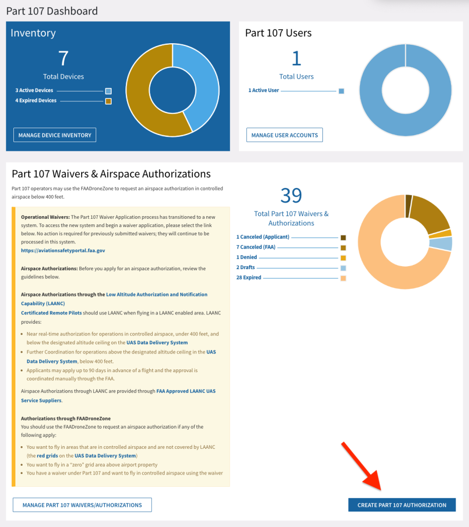
Then, once you’re logged in, click on Launch Drone Owners and Pilots Dashboard.

Navigate to the Part 107 Waivers & Authorizations section, and click the button that says, Create Part 107 Authorization.
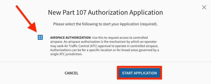
Click the button to the left of Airspace Authorization and click on ‘Start Application’.
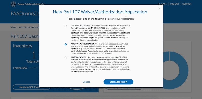
You’ll notice that there are four parts to the application.
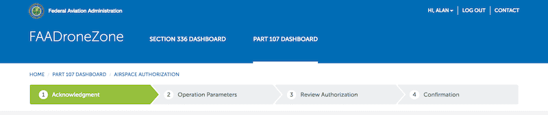
ACKNOWLEDGEMENT

Operation Title:
You need a primary title for your intended operation. My recommendation is to be clear and specific, so something like:
Ongoing Residential Roof Inspections in BNA Class C Airspace
Responsible Party:
This will usually just be you, but it doesn’t have to be. The Responsible Party is not required to hold a Remote Pilot Certificate and can be the representative of an organization.
The Responsible Party you put down is accountable for a list of responsibilities, which include maintaining records demonstrating compliance with FAA requirements; being accessible by the ATC; and maintaining a list of pilots and make / model of all aircraft involved in the operation. See the full list on pages 1 and 2 of this FAA instructions document.
OPERATION PARAMETERS

This next section of the application is called Operation Parameters and has a bunch of information you’ll need to fill out.
Pay attention to all the form field instructions, like Dates cannot be in the past or exceed 24 months from today’s date.
When it comes to your Proposed Location of Operation, the more specific you can be here, the better. Provide city, state, and specific identifying characteristics, including landmarks.
Here is an example:
Project center point is the intersection of ______________. The nearest street address is ______________. We intend to fly over the ______________ to capture photos and video for construction progress monitoring of the road/rail separation project. Flight will focus on bridge construction near this project center point as well as the railroad tracks affected by this project.
Use the Latitude and Longitude fields to identify the center point of your mission. The center point does not necessarily have to be where you are starting your mission, since factors such as weather and terrain may make starting in the center of your proposed area of operation impractical.
If you need help converting latitude and longitude decimal measurements for a particular location to the degrees, minutes, and seconds format needed in this application, you can use a conversion tool like https://www.latlong.net/lat-long-dms.html.
THIS IS IMPORTANT: A little known—but crucial!—best practice is to use the center of the airport as the GPS location and to request Blanket Area / Wide Area authorization for that airport’s entire controlled airspace. This is the clearest way to request the most amount of airspace around an airport possible.

Description of Your Proposed Operation, it’s important to note that the instructions for this open form field ask not just for a description, but also for “Purpose of operation and method by which the proposed operation can be safely conducted.”
After filling out this section of the application, you’ll be asked to review and then to submit your information to the FAA.
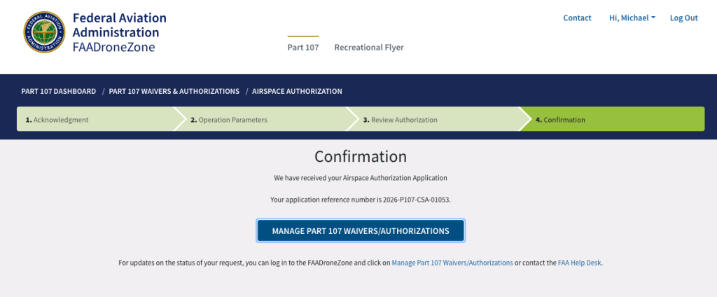
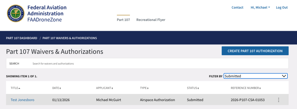
Once you submit your application, you’ll be given a reference number, and you’re able to check the status of your application at any time by logging back into your Part 107 Dashboard and selecting the Manage Part 107 Waivers / Authorizations button.
How long does it take for the FAA to process your airspace authorization request when submitted this way? It depends, but normally a couple of weeks to the full 80-90 days.
And finally, here’s a real-world example of Class C Airspace Authorization paperwork, issued directly from the FAA.
What is airspace authorization, and how is it different from a 107.41 airspace waiver?
As an FAA-certified remote pilot under the Part 107 regulations, if you need to operate in Class B, C, D, or E airspace, you need to get prior approval to operate in that airspace.
According to the FAA Drone Zone:
- When applying for airspace authorization. “Use this to request access to controlled airspace. An airspace authorization is the mechanism by which an operator may seek Air Traffic Control (ATC) approval to operate in controlled airspace. Authorizations can be for a specific location or for broad areas governed by a single ATC jurisdiction.”
- When applying for an airspace waiver. Use this to request a waiver from 14 C.F.R. 107.41. Airspace Waivers may be issued where the applicant can demonstrate safety mitigations through equipage, technology and or operational parameters that their UAS can safely operate in controlled airspace without seeking ATC authorization prior to each operation. Processing times for airspace waivers are significantly longer than processing times for airspace authorizations.
If you want to fly in controlled airspace, your best bet is to look at LAANC first, then if that doesn’t work to apply for airspace authorization using the FAA Drone Zone portal.
Read the next section to learn about the difference between an airspace waiver and a Part 107 waiver.
Is this different than getting a “Part 107 waiver?”
Yes, and this is an important distinction.
The terms “waiver” and “airspace authorization” are often used in the same sentence, and it can seem like they are the exact same thing (the confusion is understandable, in part because until recently the FAA form to apply for them was the exact same form with two different checkboxes).
In fact, many people get their application for one or the other rejected because they don’t properly understand which is which. Now that the FAA has separated Part 107 waiver requests into their own distinct form, we anticipate seeing fewer rejections of this nature.
So what’s the difference?
Part 107 (Non-Airspace) Waivers
To clarify, applying for a Part 107 waiver means that you would like to get permission to be exempt from existing Part 107 prohibitions and regulations, like not being allowed to operate beyond visual line-of-sight (BVLOS).
As of April 6th, 2021, to fly your drone at night, you no longer need to apply for the Part 107.29 Daylight Operations waiver.
See the full list of approved Part 107 waivers.
So if you want permission to fly over people from 3-4 pm on a specific day, or if you’d like to do one single BVLOS flight for an inspection, you can apply for a waiver that will temporarily exempt you from the Part 107 requirements.
Airspace Authorization
Requesting airspace authorization, on the other hand, means that you are asking to operate/fly in controlled airspace, or for drone pilots, Class B, C, D, or E:
- Class B airspace is generally airspace from the surface to 10,000 feet mean-sea-level (MSL) surrounding the nation’s busiest airports in terms of airport operations or passenger enplanements. You can think of the “B” in Class B airspace as standing for “big city” airports.
- Class C airspace is generally airspace from the surface to 4,000 feet above the airport elevation (AGL) (charted in MSL) surrounding those airports that have an operational control tower, are serviced by a radar approach control, and have a certain number of instrument flight rules (IFR) operations or passenger enplanements. You can think of the “C” in Class C airspace as standing for “cities.” So not the big cities of Class B airspace, but still sizable city airports.
- Class D airspace is generally airspace from the surface to 2,500 feet AGL (charted in MSL) surrounding those airports that have an operational control tower. Small city airports with control towers are usually designated as Class D airspace. You can associate the “D” in Class D airspace with “diminutive” or “dime-sized.”
- Class E airspace almost always has one of four lower limits: the surface, 700 feet AGL, 1,200 feet AGL or, in some sparsely populated areas, 14,500 feet MSL. Most of the country has a Class E airspace lower limit of 700 feet AGL and/or 1,200 feet AGL. The upper limit of Class E airspace is up to but not including 18,000 feet MSL, or when Class E airspace runs into the upside-down wedding cake airspace of Class B or Class C. For a drone pilot, if you’d like to operate in Class E airspace, you’ll need to get permission.
What if I need a Part 107 waiver AND airspace authorization?
If you are planning a flight that will require both a Part 107 waiver and airspace authorization—for example, night operations in Class B airspace—the order in which you get each is important.
From FAA.gov:
“If you intend to use a non-airspace Part 107 waiver in controlled airspace (for example, night operations in Class B airspace), you must obtain your non-airspace waiver prior to requesting an airspace authorization or airspace waiver.”
So if you want to fly a mission that requires both a Part 107 waiver and airspace authorization, you must obtain your Part 107 waiver prior to requesting an airspace authorization or airspace waiver.
Since Part 107 waivers have historically been slow to process, you should prepare yourself for a long wait—especially since you’ll have to use the Part 107 waiver to then submit your airspace authorization request . . . and wait some more while that gets processed.
I heard I could just contact the airport/air traffic control directly…isn’t that faster?
No.
On the FAA’s website, they state their position quite clearly:
How do I request permission from Air Traffic Control to operate in Class B, C, D, or E airspace? Is there a way to request permission electronically?
All airspace authorization must be made through the Low Altitude Authorization and Notification Capability (LAANC) or DroneZone.
Can I contact my local air traffic control tower or facility directly to request airspace permission?
No. All airspace permission requests must be made through the online portal.