Let’s imagine you’re flying a drone—or piloting a plane—and you want to know how high you are.
But wait! Are we talking about your height above the ground, or your height above sea level?
That’s where AGL and MSL come in, and understanding the difference is crucial for pilots, drone operators, and aviation enthusiasts alike.
Above Ground Level (AGL): Your Height Above the Ground
AGL is the literal height above the ground or surface you fly over.
If your drone is hovering 300 feet above a hill, that 300 feet is your AGL.
Fly over a valley, and your AGL increases, even if your drone stays at the same altitude.
Mean Sea Level (MSL): Your Height Above Sea Level
MSL, on the other hand, is your height measured from the average sea level across the globe. This isn’t a static number—scientists calculate it based on tidal data collected over 19 years. It gives a universal reference point for altitude.
So if you’re flying at 10,000 feet MSL, that’s your elevation above the average sea level—even if the ground beneath you rises or dips.
So, What’s the Difference?
AGL changes depending on the terrain below you. Fly over a mountain, and your AGL shrinks. Fly over a canyon, and it grows.
MSL, on the other hand, stays consistent for your altitude, regardless of what’s happening below.
Quick Tip for Sectional Charts
On a Sectional Chart, all of the numbers you see that state altitudes are in MSL, unless they are in parentheses. If you see a number in parentheses, that indicates it’s in AGL.
For example, when we look at Cooperstown Airport, this 1,424 number indicates that the airport sits at 1,424 ft mean sea level (MSL).

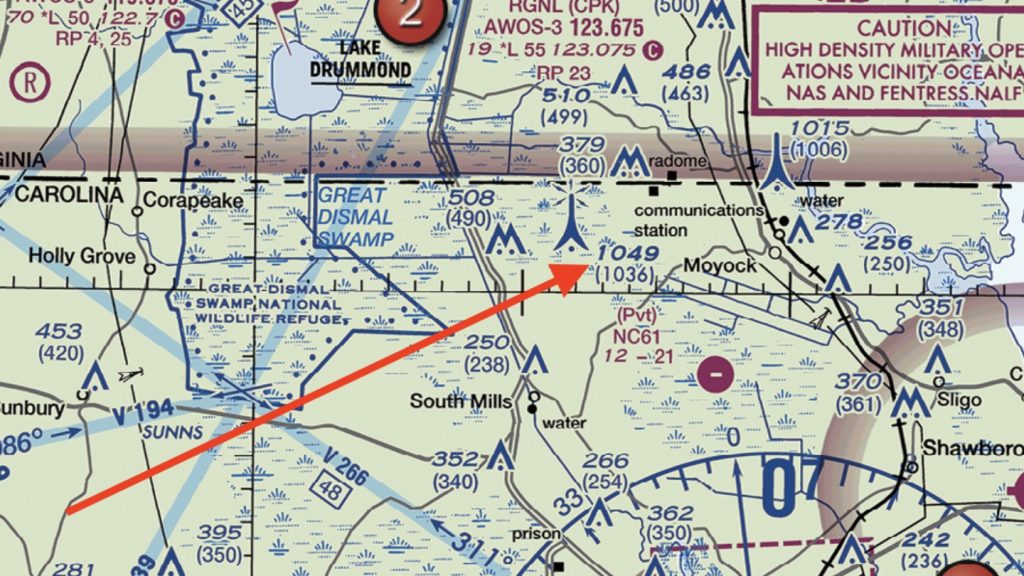
When it comes to towers and other obstructions, these are what they look like on a Sectional Chart.
Check out this lighted tower.
You will see “1049 (1036)” next to the symbol. This means that this tower is 1,049 feet MSL and 1,036 feet AGL.
If you were standing at the base of this tower, it would rise up exactly 1,036 ft from where you’re standing. But the MSL height is a little higher given the terrain elevation above sea level.
If you’re studying for your FAA exam, you’ll see some tricky questions that involve these obstruction icons and AGL vs. MSL. The good news, remember, is that these obstruction icons are included in the Sectional Aeronautical Chart legend that you have access to during your test, right after that Table of Contents.
What About Airspace Altitudes?
What about airspace? Which classes of airspace are charted in MSL and which classes are AGL?
Remember that on a Sectional Chart, any number indicating altitude (unless it is in parentheses) is charted in MSL, mean sea level.
So Class B and C, with the fractions that denote the floor and ceiling altitudes, those numbers are MSL. Same with Class D and the bracketed number. That’s also MSL.
The only airspace that is referenced in AGL is Class G and Class E Transition airspace that starts at either 700 ft AGL (inside the thick fuzzy magenta lines) or 1,200 ft AGL (when nothing is marked).